Gechang Fm
Type Locality and Naming
Type section is in Not defined in Zanskar region (in Spiti it represents in Lingti section (Bhat and Joshi, 1981; ND: Gechang village in Parahio Valley of Spiti. [Original Publication: Srikantia, S.V., 1981. The lithostratigraphy, sedimentation and structure of Proterozoic–Phanerozoic formations of Spiti basin in the higher Himalaya of Himachal Pradesh, India. In: Sinha, A.K. (Ed.), Contemporary Geoscientific Researches in India (a commemorative volume in honor of S.P. Nautiyal). Bishen Singh Mahendra Pal Singh, Dehra Dun, pp. 31–48.]
Synonyms: Calcareous Sandstone (Hayden, 1904)
[Figure: Zanskar-Spiti-Kumaun region location (provided by Om Bhargava)]
Lithology and Thickness
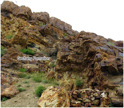
Sandstone. 10-35 m thick coarse hybrid-sandstone and calc-arenite with shale beds and alternating layers of calcareous sandstone and conglomerate. Commonly the rocks are light brown to grey, pale grey, rusty medium to coarse–grained sandstone, siltstone, shale and conglomerate. It is noteworthy that the thickness of the Gechang Formation in the Spiti region decreases progressively from NW (35 m at Losar locality along the Ganmachidam Hill) to SE direction (~10 m in Parahio Valley).
[Figure 1: Field photograph of the Gechang Formation near the Guling Village in Upper Pin Valley, Spiti (after Singh et al., in review)]
[Figure 2: a) Vertical section of the Gechang Formation near the Gungri village in the Upper Pin Valley (after Singh et al., in review)]
Relationships and Distribution
Lower contact
Upper contact
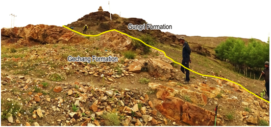
Sharply underlying the Panjal Volcanics Fm in Zanskar region (according to Lexicon entry on Panjal Volcanics Fm); which, in turn, has a sharp contact with black shales of Gungri Fm. A major unconformity spanning from late part of Artinskian (278 Ma) to early part of Wuchiapingian (258 Ma) has been proposed between the Gechang Fm and the Gungri Fm (Bhargava and Bassi, 1998).
[Figure 3: Field photograph showing the contact of Gechang and Gungri Formations near the Guling Village in upper Pin Valley, Spiti.]
Regional extent
Zanskar-Spiti and Himachal Pradesh to Kumaun-Garhwal region of Northwest Tethyan Himalaya. In the Spiti region, the Gechang Formation disconformably overlies various sedimentary units ranging in age from the Silurian to the lowermost Permian due to pre–Permian erosion (Bhargava and Bassi, 1998). In the Spiti region at Losar and the Poh localities the Kuling Group rests over the Ganmachidam Fm (Carboniferous to ?Asselian) (Bhargava and Bassi, 1998). However, in the upper Pin and the Parahio valleys (Spiti region) the Kuling Gr rests disconformably over the Lipak Fm (Lower Carboniferous), Muth Fm (Muth Quartzite) (?Late Silurian–?Devonian) or even the Takche Fm (Late Ordovician–Early Silurian).
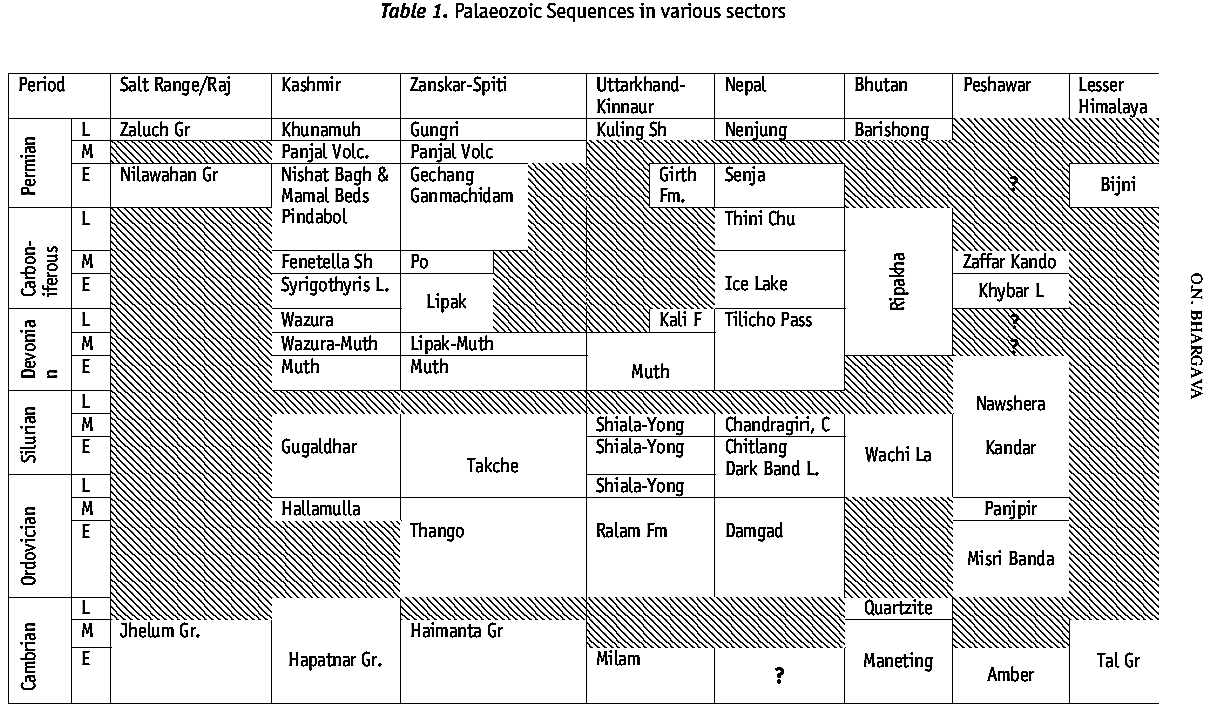
[Figure: Paleozoic successions of Himalayas West-to-East (after Bhargava, 2008)]
GeoJSON
Fossils
Brachiopods Lamnimargus sp., Spiriferella rajah, Duplophyllum, Waagenophyllum, Eurydesma-Deltopecten assemblage, Eurydesma cordatum, Deltopecten cf. mitchelli (Srikantia et al., 1978; Srikantia, 1981), E. manendragarhensis and E. hasdoensis (Bhargava et al., 1985), Trigonotreta cf. orientensis in the lower part and Neospirifer sp., and Fusispirifer sp. (Garzanti et al., 1996) and bryozoans Dyscritella sp., Rhombopora sp., Sulcoretepora sp., and Polypora sp. (Sakagami et al., 2006).
Age
Depositional setting
Garzanti et al. (1996) inferred high-energy shoreface and estuarine channel setting. Bhargava and Bassi (1998) and Bhargava (2008) inferred foreshore to upper shoreface environment.
Additional Information


 Vertical section of the Gechang Formation near the Gungri village in the Upper Pin Valley.jpg)

